Apps, Social Media, and The Day the Music Died (about 60 miles outside of Lugo)
Last year while walking, my iPhone battery had a (literal) meltdown. I count myself fortunate that it waited until a week into the Primitivo before expiring - if it had happened while I was walking the Camino San Salvador the previous week, I would probably still be standing in a cow pasture somewhere in Spain. The Primitivo is well marked though, so navigation wasn’t a problem but I missed listening to music! There are numerous difficult ascents on the road to Lugo, and I could have used Van Morrison’s help to make it up a few of them. And of course, no photos - for a week. The wonderful group I walked with on and off again were gracious with their cameras, and I so appreciate their care in taking pictures for me while we walked. I’ll be honest though, between the phone issue, a pretty serious head cold and the lack of an iPhone 12 replacement battery anywhere in Spain, I had two days that seemed bleak.. And as usually happens while walking the Camino, you are challenged to take charge of your thoughts, and look for the positive.
It was good to walk a bit without the distraction of a phone. I’m hoping it’s not something I’ll “get” to experience again, but there are definitely benefits for being truly unplugged. I’m going to be working on setting it aside more on my next Camino - I don’t need to be checking on distances nearly as much as I do, but having said that, here’s what I actually do use, when my phone’s not melted.
There’s a wealth of books, apps, and blogs covering how to navigate the Camino. I’m going to share a few with you that I like, as well as hopefully familiarize you with them. There’s no substitute for practice though, so make sure you’re playing around with them a bit before you start!
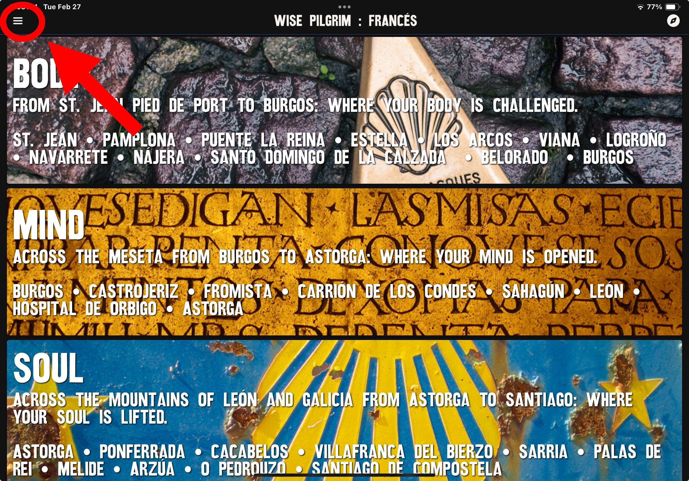
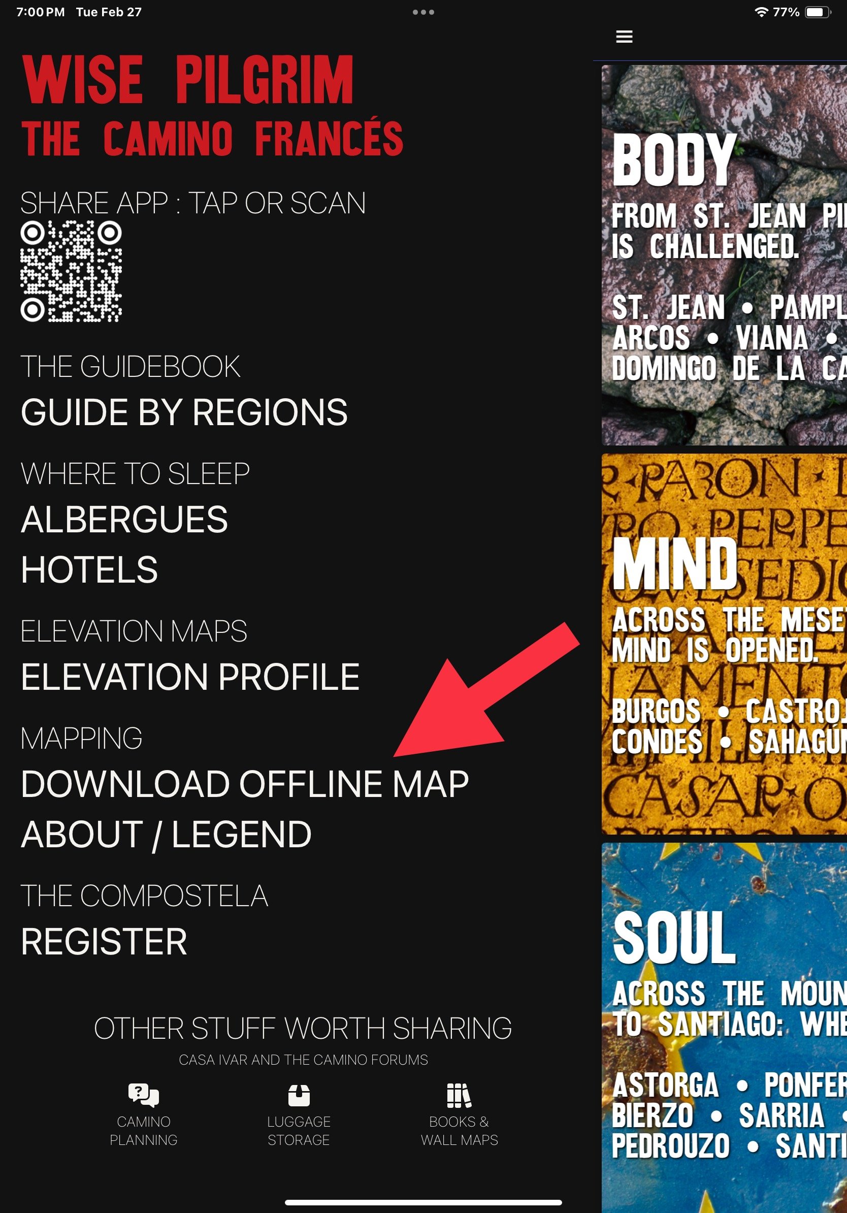
The two apps I use the most are Wise Pilgrim (the paid version) and Camino Ninja (free). The route I’m showing here is the Frances, on Wise Pilgrim. You can see how the app divides the Camino into three parts: Body, Soul, and Mind. If you click the three lines in the upper left corner, the app will open to a page that lists the regions, the complete list of albergues and hotels in order of the towns you’ll be walking through, an elevation map of the route and an offline map that you’ll need to download. At the bottom of the page is a link to register for your Compostela upon completion of your journey, contact information and a video for Casa Ivar for those sending suitcases ahead to Santiago, as well as a direct link to the Camino Forum for planning purposes.
The above photo shows the prompt for the elevation profile, and what a section of that looks like. The third picture shows the place to download the offline map, and a screenshot of what that map looks like. You may choose to use it with or without the pins. The example I’ve posted shows Puente La Reina, and symbols showing both food and lodging. Alternate routes are shown in different colors on the map, with the corresponding information showing in the matching color in the route guide Wise Pilgrim does a fantastic job of giving interesting historical information, and is very up to date.
I’ve chosen the town of Puente la Reina from the main page of the app, in the “Body” section. You can see to the left of the label, the site is showing 82.9km, which is how far this location is from Saint Jean Pied de Port. The second photo shows what happens when I swipe left on the town; a heart and a pinpoint symbol show up. By clicking on the pinpoint, you’ll see that the 82.9km disappears and you’re left with a green 0km. Now you can look down the list and see how many kilometers it is to the next village or city, as well as the distance between each location.. The right hand number is the miles to Santiago. By clicking on the heart, you’ll highlight the city - a handy thing if you’re looking for an easy way to keep track of your journey.
Clicking on the city takes you to a listing of albergues and hotels. Booking.com listings will be in blue, and you have the option of going straight to their site if they have contracted with owners in the city. If you were to click on the name of Albergue Estrella Guía, you’d learn that they are open March 1-December 31, they open daily at 1:00 pm, they have 6 bunks at 19€, and rooms for 48€. The phone number is listed, as well as a direct link to WhatsApp, and a website, if available. You’ll also find social media links, and any reviews others have left. Please note - albergues sometimes show as closed when they are actually open, and vice versa, so it’s always a good idea to make contact if you have your heart sent on staying at a certain location.
Camino Ninja is another app that I use in conjunction with Wise Pilgrim. You first choose what route you’re walking, then a start and end point along that route. The picture above shows I’m starting at Pamplona and ending at Puente la Reina. I like this app because it adjusts as I walk during the day, so I can stop at any point and see how long I have to walk for lunch or a break. For example, from this I can see I’ll walk 11.2km before I can have my second breakfast - these are important facts! I can also click on Puenta la Reina and the app will show me what’s available in the town, as well as important contact information. Camino Ninja also has an offline map function as well.
There are several other apps available, such as Gronze and Buen Camino, which are popular as well. Buen Camino is one I’ll be using for a section of the Primitivo this September. After Lugo, there’s a path known as the Ruta Verde which leaves the Primitivo and joins in two day’s walking time to the Norte. It’s supposed to be a pleasant walk as well as a good way to avoid the rush when the Primitivo joins onto the Frances. Buen Camino is one of the few apps that shows the route on its GPS map, although I’m sure other apps will be adding it as lesser-walked stretches become more popular.
A couple of additional sites that are helpful for planning are www.caminoweather.com and rome2rio.com.
If you’re going to be posted things for family and friends, a wonderful way to do so is through the app Polarsteps. It’s a free travel tracker app that drops GPS breadcrumbs while you walk.The app uses very little memory, so the “cost” in terms of battery drainage is minimal. Pictures you take along your route are tied to the app, so you have an online picture book of what your day has been. You can add travel notes as you go, and friends can comment on your journey. You’re able to purchase a book upon completion of your walk, if you’d like something to commemorate the walk. I’m hoping to do this when I walk the Primitivo again with my son in September. Similar apps aer Wayzaway, Prada and Journal Together. It’s a fun thing to use on any trip, and you’ll find it fairly easy to use.
Last but not least, the books! I love, love, LOVE the Village to Village Guides. I have used them for every Camino I’ve researched, other than the San Salvador (I used Ender’s Guide and Wise Pilgrim for that one). Village to Village Press has online resources for maps, lodging, packing, etc, and the listings for accommodations are much easier to read than John Brierly’s, IMHO. And as a last thought, remember that you can often use the “translate” prompt on your phone for many types of communications, if you’re not a native speaker!
Phew - That’s a lot of information! Hopefully you’ll find some of it helpful. Now I’m off to read another Camino book!


